Coastal regions are diverse ecosystems that support a myriad of economic and societal services. Various industry stakeholders, such as port authorities, shipping firms, tourism operators, and fisheries, to name but a few, rely on coastal habitats and their resources. These environments, unlike inland ones, face unique challenges in terms of coastal resilience and vulnerability, factors that are acerbated by their ongoing exposure to extreme weather and erosion.
Just this past year, the National Oceanic and Atmospheric Administration (NOAA) announced Hurricane Ian, a deadly and extremely destructive Category 5 Atlantic hurricane that produced catastrophic storm surge, winds, and unprecedented flooding across much of central and northern Florida as the costliest hurricane in the state’s history and the third costliest on record in the United States. Having made landfall initially in Cuba, then Florida, and finally North Carolina, the storm tallied up a bill of $112.9 billion. As extreme weather events of this magnitude continue to impact coastal regions with increased frequency, the need to establish enduring and cost-effective protections and response practices remain paramount for coastline communities.
Planning authorities have begun to research and enact solutions for coastal flooding and erosion. Resilience structures—whether artificially engineered or restored natural environments—have proven successful in reducing storm damage. Overtime, proactive measures to mitigate destructive forces have included the use of manmade structures like artificial reefs, erosional deposition pits, groins, and jetties—all come with pros and cons.
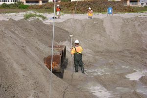
Surveying dredge discharge pipe elevations during beach renourishment project. (Image credit: M&E)
Additionally, the restoration of natural marine environments, such as coral reefs, seagrass meadows, and mangrove forests, has also helped abate the cumulative cost of constant wave action and the increased sediment deposition associated with it. While these interventions may seem straightforward, coastal managers and practitioners must assess risk, cost, and effectiveness before implementation, as well as monitor the success of such projects ongoing.
ENABLING TECH-LED PROGRESS
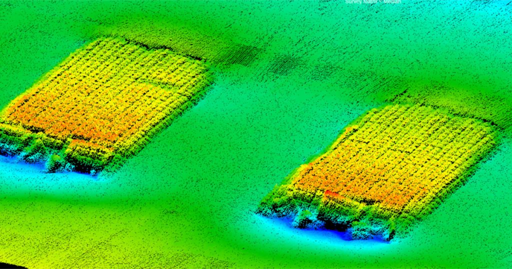
Hydrographic survey provides much of the data needed to support coastal resilience engineering and decision-making. For 37 years, Morgan & Eklund, Inc. (M&E) has been providing accurate and robust hydrographic and geophysical data to engineering firms, marine construction contractors, and federal, state, and local governments to help them make sound, defensible decisions. Whether running survey campaigns for beach restoration or marine and coastal infrastructure projects, M&E has built a team of experienced and talented subject matter experts (SMEs), supported by an expanding toolkit of the latest technologies, to deliver best-in-class marine data.
When in the field, M&E surveyors rely on several well-established technologies—including side-scan sonar, LiDAR, RTK GPS, and multibeam echo sounders. In recent years, however, we have also invested significantly in the growing utility of autonomous survey vehicles (ASVs). Our current ASV of choice is a SeaRobotics SR-Surveyor M1.8. With its catamaran hull design, the SR-Surveyor M1.8 is a highly portable autonomous platform equipped with a multi-sensor package that includes an EdgeTech 2205 multibeam echosounder, a 1,600 kHz and 540 kHz dual-beam side-scan sonar, an AML Oceanographic SV sound velocity sensor, and a Velodyne LIDAR for mapping features above the water surface.
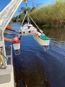
Launching SeaRobotics M1.8 ASV from work boat to perform oyster mapping survey. (Image credit: M&E)
The ASV’s capacity to capture such a diverse range of data sets alongside its portability and ease of deployment deliver a series of game-changing benefits to M&E operators, and so subsequently, our customers. Over the last 36 months, we have tracked a significant reduction to in-field operating costs, gains that we consistently share with our clients.
The use of ASVs, including the deployment of multiple units at one time in swarm format, is slowly bringing about a new streamlined approach to gather better data, quicker, at without putting people in harm’s way. We tend to use compact, quick-to-deploy ASVs as we also need to navigate coastal waters that can be trick to navigate for a conventional research vessel, but the growing range of commercial ASVs on the market is a sure sign that the future of marine survey will lean in heavily on our industry’s capacity to thread autonomy into our day-to-day operations.
FORGING LONG-LASTING PARTNERSHIPS
M&E’s local and regional relationships with key clients—the Army Corps of Engineers, the Florida Department of Environmental Protection (FDEP), Olsen Associates Inc., Stantec Consulting, and various Florida counties—have enabled novel collaborative methodologies for completing coastal projects on time and on (a more manageable) budget.
Just recently, M&E was a recognized player in an innovative beach restoration project performed by three coastal municipalities and three engineering consulting entities. Through a subcontract by both the construction company and coastal engineer, M&E collected essential data required by FDEP that was instrumental in ensuring the successful completion of the beach nourishment project.
Due to the project’s successful partnership between multiple municipalities and consulting agencies that exemplified the use of shared permits and provided a unified workforce to meet the needs of a cost-effective renourishment project, it earned the American Shore & Beach Preservation Association (ASBPA) Award of 2023 Best Restored Beach. Collaborative projects like these, aided by the expanding capacity of some of the specialized marine survey equipment readily available on the market—especially those, like ASVs, that are bringing real-world efficiencies to the field—are setting new standards in using defensible ocean data for coastal restoration and reliance projects in the future.
This feature appeared in ON&T Magazine’s 2023 December special edition: The Future of Ocean Technology, Vol. 4, to read more access the magazine here.
