Despite the rather bleak outlook published by the National Oceanic and Atmospheric Administration (NOAA) Climate Prediction Center (CPC) in April, until late September, the 2022 Atlantic Hurricane season had proven, by historical standards at least, relatively benign.
Then, on September 26, Tropical Storm Ian, only the ninth named storm of the season, became the fourth hurricane—and second major hurricane—of 2022. Having impacted Cuba as a high-end CAT 3 system, it made landfall on Florida’s east coast, near Punta Gorda, as a strong CAT 4, bringing sustained winds of 150 mph and a deadly storm surge. (Hurricane Ian has been confirmed as the deadliest to strike Florida since the 1935 Labor Day hurricane, claiming 157 lives in total, 146 in Florida.) Ian went on to cause widespread damage throughout the state before reentering Atlantic waters, and after this intensified again and made its second landfall in the US, this time South Carolina, as a CAT 1 hurricane. The financial toll for this year’s villain is estimated to be over $50 billion.
Whether this season’s final reckoning of 14 storms, 8 hurricanes (3 of which uncharacteristically formed in November), and 2 major hurricanes qualifies as “above-normal” activity is perhaps debatable. Still, the general uptick in extreme weather events over the last decade is less questionable. 2020 ranks as the most active Atlantic Hurricane season (June through November) on record (30 named storms), while 2021 (21 named storms) grabs third spot, denied only by 2005’s infamous record of 15 hurricanes—7 major—and the well-documented devastation caused by Hurricane Katrina.
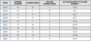
The ten years before 2022’s Atlantic Hurricane season show a pronounced uptick in cyclonic activity (Source: Colorado State University).
COASTAL PRESERVATION MEASURES
Any variance in season forecasting, despite the extensive data and modeling capabilities, clearly creates challenges for the authorities charged with planning the necessary interventions designed to preserve coastal environments. Naturally, beaches and coastal communities bear the brunt of landfall interactions, and their concession to storm surge tends to swamp the media spotlight. But we can only fully assess the physical damage to shorelines once the storm passes and the waters recede, with beach erosion and sediment displacement of paramount concern.
The pressures placed on beach nourishment projects around the US coastlines, especially in Florida, highlights the extent of the problem. According to the National Beach Nourishment Database, which has been compiled over the last two decades and is updated annually by members of the American Shore and Beach Preservation Association (ASBPA), across 81 communities in Florida, there have been as many as 753 registered beach nourishment events, dating back to 1935.
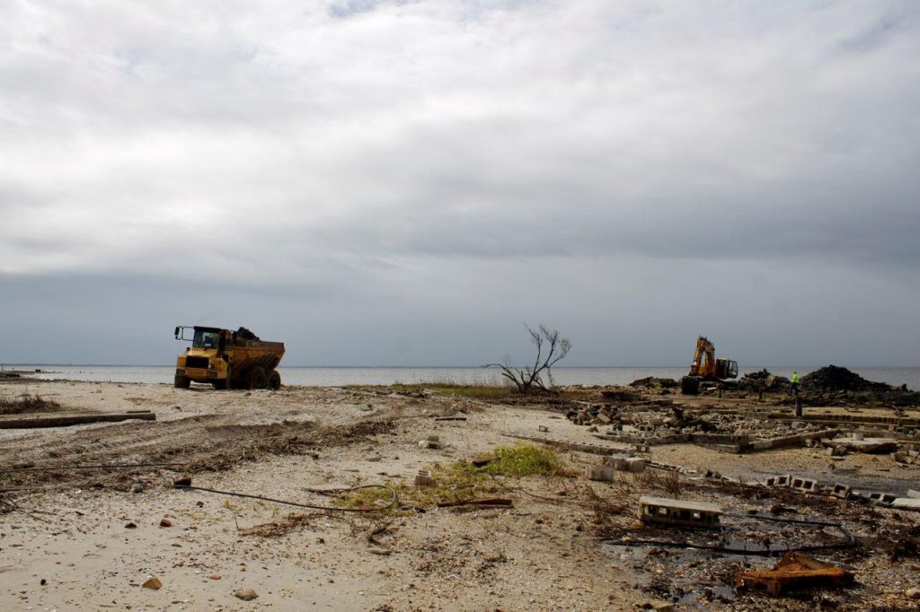
The Atlantic Hurricane season has a profound consequence on Florida’s coastlines and drives the need for ongoing beach restoration and nourishment projects.
Cumulatively, these projects amount to nearly 350,000,000 cubic yards of sand being strategically placed on 288.1 miles of beachfront at the compounded cost of over $1.9 billion. This constant investment in shifting sands represents an ongoing battle with nature to make coastal regions—and the communities that call them home—hurricane resilient.
RAPID RESPONSE SURVEY SERVICES
The measured execution of coastal restoration and beach nourishment projects relies heavily on surveyors to monitor the shifts in hydrographic and topographic variables on a particular stretch of the coast. This is an important part of what we do at M&E. We have been working with public and private sector clients for nearly 40 years to identify the cumulative impacts of extreme weather events through wading profiles with hardbottom mapping, onshore/offshore beach profiling pre- and post-event, multibeam surveys of artificial reef structures, and the inspection of dune conditions. Our goal is to assist authorities with the precise data required to trigger and monitor the most appropriate restorative action.
With greater frequency—and intensity—of storm events, time is of the essence. A major landfall, especially if it hits during an exceptionally high tide, will leave a stretch of coastline perilously exposed to repeat events. Our customers rely on our ability to rapidly mobilize and acquire and process the data they depend on.
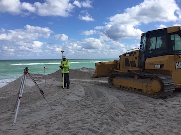
Coastal restoration and beach nourishment projects rely heavily on surveyors to monitor the shifts in hydrographic and topographic variables.
To further streamline this process, our field teams deploy some of the most recent innovations in marine survey technology. For accurate analysis of shifting sediment, in the surf zone, Intracoastal waters, or up and down the many manmade inlets around which so many communities dwell, surveyors rely on mapping above and below the waterline to render a 360-degree view of all data points.
In recent years, we have capitalized on the advances in compact LiDAR systems and integrated them into some of the uncrewed assets we deploy to gather multibeam data. The synergy between this new generation of “pucks” and the latest multibeam sonars translates into immediate operational efficiency for all stakeholders.
UNCREWED SYSTEMS
The ability to incorporate these and other relevant sensors into the payloads of Autonomous Surface Vehicles (ASVs) also affords us access to potentially hazardous waters. Geodata not only allows dredgers to plan interventions but also identify the quantity, size, and distribution of any storm-related debris, which in some cases can pose a significant threat to navigation.
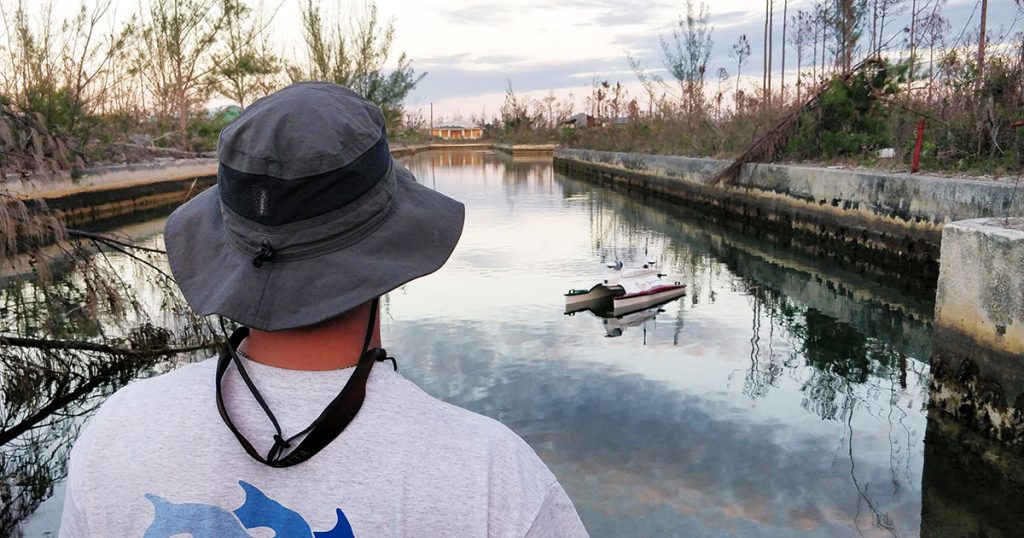
We are currently mobilizing a team to the city of Naples, Florida, to survey the damage caused by Hurricane Ian. In addition to our standard survey toolkit, we will also be deploying one of our ASVs—a SR-Surveyor M1.8 (SeaRobotics)—both as a means of force multiplication and to access some of the more hard-to-navigate inlets, which are likely littered with debris. The portability and modular versatility of ASVs allow us to run quick spot surveys of manmade structures found in some of the inlets, such as vertical sheet pile walls and bulkheads, as well as hard-bottom mapping and beach profiling.
The growing acceptance of uncrewed vehicle technology for the survey of hurricane-prone coasts essentially equates to better data (advances in sensor accuracy marginalize human error), quicker (rapidly deployable force multipliers allow surveyors to focus on real-time data processing, not the handling of instrumentation), and for cheaper (fewer in-field overheads and topside support needed).
For more information, visit: www.morganeklund.com.
